

The National Hurricane Center (NHC) has issued an urgent warning about Hurricane Milton. It has intensified into a dangerous Category 5 storm. With sustained winds reaching 165 mph and a central pressure of 995 millibars, Milton poses an imminent threat to the Florida Peninsula. Multiple life-threatening hazards are expected as the storm approaches the west coast of Florida, particularly during the late evening of Wednesday, October 9, and the early hours of Thursday, October 10.
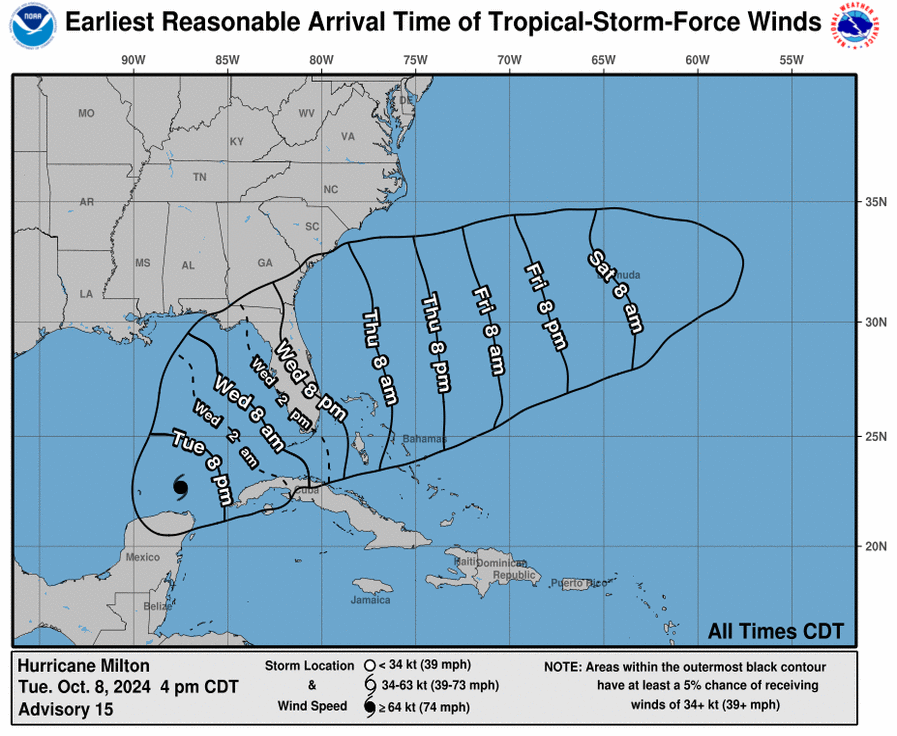
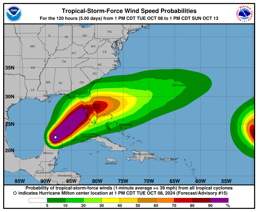
As of today, the NHC reported that Hurricane Milton had re-strengthened significantly, with satellite data confirming the storm’s rapid intensification. The eye of the hurricane has become more distinct, signaling further strengthening. Milton is currently located approximately 475 miles southwest of Tampa and is moving northeast at 9 mph.
Forecasters anticipate Milton will maintain its catastrophic strength as it nears the Florida coastline. The NHC has emphasized that this hurricane is not just a wind threat, but a multi-faceted hazard with the potential for destructive storm surge, flooding, and high winds across a wide area.
A storm surge warning has been issued for nearly the entire west coast of Florida, from Flamingo to the Saanai River. The most vulnerable area extends from Bonita Beach to Chassahowitzka, where inundation levels could exceed five feet above ground. However, the greatest concern lies in the Tampa Bay region and surrounding counties, where water levels may reach between 10 to 15 feet above ground level, putting the area at significant risk for catastrophic storm surge.
This surge will not simply rise slowly like a bathtub filling up—it will be pushed violently inland, carried by powerful winds, and amplified by destructive wave action. The NHC warned that buildings in low-lying areas may sustain severe structural damage or even wash away entirely.
In addition to the storm surge, Milton is expected to bring widespread hurricane-force winds to much of central and northeastern Florida. Hurricane warnings are in effect from Bonita Beach northward to the Suwannee River and along the east coast, extending from St. Lucie County to Ponte Vedra Beach. The wind field of the hurricane is predicted to double in size by the time it reaches land, increasing the scope of potentially devastating wind damage.
The wind threat extends well inland. The I-4 corridor from Tampa to Orlando and Daytona is particularly at risk, as are cities like Sarasota, Port Charlotte, and St. Augustine. The NHC warned of extensive tree damage, downed power lines, and widespread power outages starting Wednesday night and continuing into Thursday.
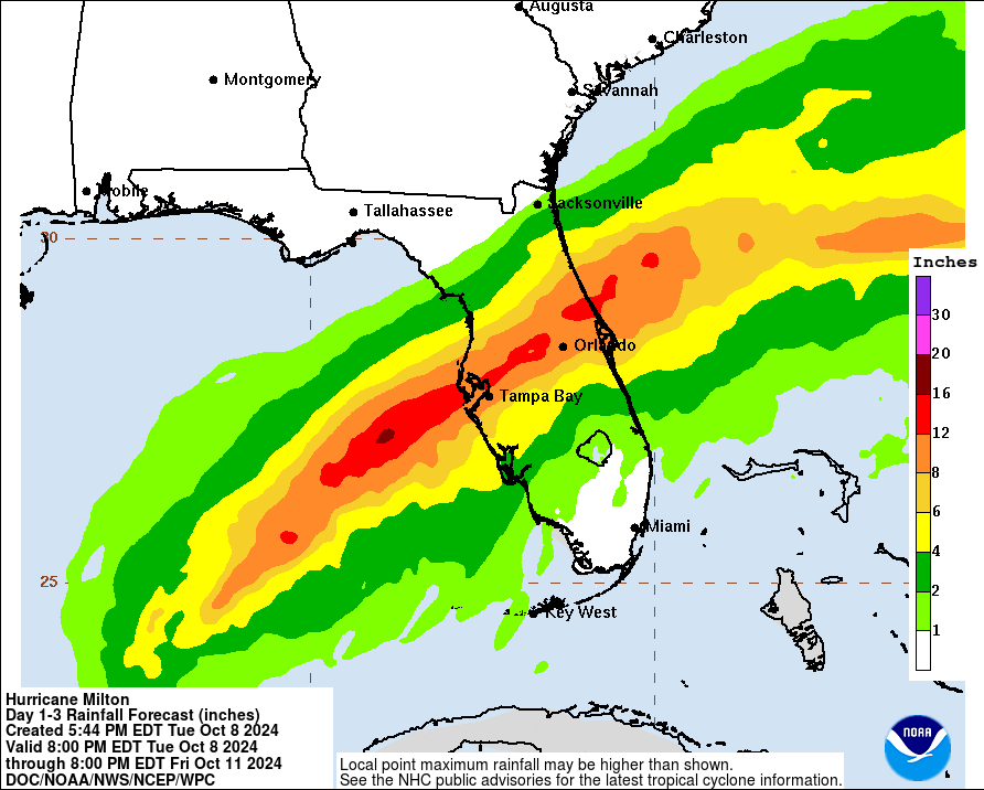
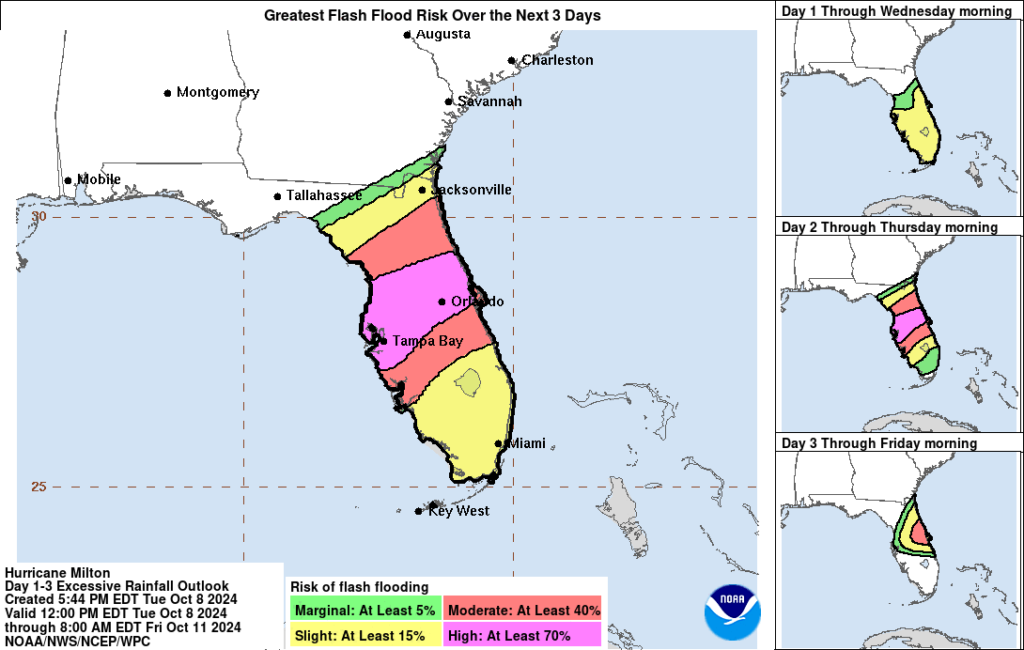
Milton is forecasted to bring 5 to 12 inches of rainfall across central and northeastern Florida, with isolated areas receiving up to 18 inches, particularly along the I-4 corridor. The risk of flash flooding in urban and rural areas is extremely high.
For more information on Hurricane Milton and its local impacts, visit hurricanes.gov or your local National Weather Service office at weather.gov.
As Hurricane Milton approaches, our thoughts are with all those in its path. We urge residents to prioritize safety, follow evacuation orders, and take necessary precautions to protect themselves and their loved ones. Stay informed, stay safe, and know that our hearts are with you during this challenging time.